|
One of the earliest officially recorded uncontrolled fires in, the then, Bald Rock Creek National Park was during the 1950s when a fire started behind Slip Rock and burnt around the present day First Pyramid.
In 1965, a devastating bush fire - suspected to be deliberately lit - completely burnt out both Castle Rock and Bald Rock Creek National Parks. Bill Goebel was asked by the Forestry Department to round up some locals to try to put out the fire. It was agreed that the fire was unable to be stopped and it was left to burn. Bill did manage to save some Superb Lyrebird habitat behind his property by using a branch to swat out the flames.
A fire in 1980, possibly started from a local burn-off, burnt all of the northern section of Girraween National Park (the Pyramids side of park). The same area was burnt out again in 1989.
In October 1994, lightning ignited a bush fire in a gully below the Cascades (west of Dr Roberts' Waterhole). It burnt over half of the park - mainly on the Mt Norman side of the road - and was eventually controlled on the Mount Lindsay Highway, south of Bald Rock National Park in New South Wales.
A small fire occurred in March 1998, near the Stone House extending to West Bald Rock.
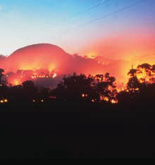
Girraween National Park experienced its worst bush fire to date in October 2002. The blaze started on the 15th of October, west of Ballandean on a private property when arcing power lines ignited a grass fire. Hot north-westerly winds pushed the fire very quickly through dry country in Ballandean, where it jumped the three lane New England Highway and headed towards Eukey, eventually arriving in Girraween National Park two days later, on the 17th.
It was a devastating bush fire for the local community. Tragically, one person was killed, a fire-fighter was injured, eight homes were destroyed and much infrastructure was damaged.
The effect on the park was highly evident as well with almost three quarters of the park burnt. The fire continued to burn in Girraween for three weeks while its front moved south-east to Drake, on the Bruxner Highway. Together with the effects of drought, Girraween took over six years to show signs of recovery from this fire.
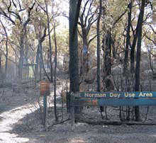
While many were enjoying Christmas day 2005 with their families, spare a thought for the Girraween staff and local fire-fighters who were called away from their celebrations to save the park from yet another bush fire! This fire had been started by a dry lightning strike and it had burned for a day before it was detected. It had started behind the Mt Norman day-use area and burnt from the Stone Cottage to West Bald Rock and around to Mt Norman road. Unfortunately, the infrastructure at the Mt Norman day-use area was destroyed by the fire.
During September 2007, neighbouring Bald Rock National Park battled with a bush fire east of South Bald Rock. A back-burn from South Bald Rock north along the border trail prevented this fire from entering Girraween National Park.
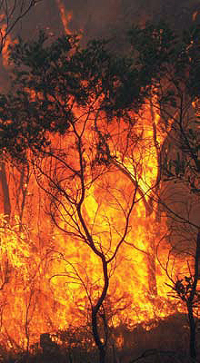
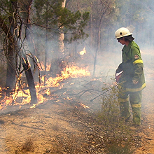
Almost twelves years to the week since the tragic 2002 fire, another blaze started on 28th October, 2014. The fire reportedly began after a slasher hit granite at a Ballandean property. The fire, aided by winds of up to 45km, headed eastwards and Ballandean and Eukey homes became under threat. Rural firefighters worked with Queensland Parks and Wildlife crews to defend the properties, primarily through back burning exercises. The fire was kept within its containment lines and was mostly isolated within Girraween National Park. Nearly a third of the park - about 3000 hectares of shrubby open forest and heath - was burnt out.
More photos of the 2014 fire...
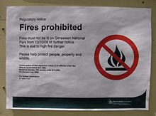
It is evident, from 50 years of recorded fire history, that the worst times of the year for fires are the spring and summer months. Extreme weather conditions, such as drought and lightning, are the main factors behind fires. In extreme fire danger periods, the park may be closed to reduce the threat to human life and minimise the risk of carelessly-lit fires.
Please remember to always observe fire bans in the park.
Since the mid 1970s, professionally-trained Girraween National Park staff have used cool winter prescribed burns as a fire management tool. The fire management program is carefully planned, implemented and monitored by these specialists. Reducing the level of available fuel decreases the number and severity of wildfires and reduces the risk to wildlife, park facilities and adjacent properties.
Controlled burns also conserve and promote natural systems and processes. Fire is a natural phenomenon and the Australian bush is adapted to it. The frequency and intensity of burning is controlled to maintain conditions suitable for native plants and animals.
Next...
Chapter 6 - A Bright Future.
|