The Pyramid track is accessed from the Granite Arch track, about 500m from the Bald Rock Creek day-use area. The first part of the walk is fairly easy, crossing the creek by bridge and winding through pleasant bushland. When the track reaches the base of The Pyramid, it becomes quite steep — with lots of stairs and it can be hard going. The track reaches the tree-line and continues upwards across the steep, exposed rock faces of the granite dome. The climb is well worth the effort.
|
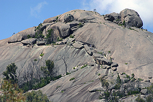
|
At the northern side of the top (elevation: 1180m) is a large, balancing rock. There are also excellent views of the park. To the east is Bald Rock and to the south are Castle Rock, Mt Norman, the Sphinx and Turtle Rock. Immediately to the north is the bare dome of the Second Pyramid. There isn't a walking track to the Second Pyramid and you need considerable rock climbing experience to be able to scale it.
Warning:
The summit of The Pyramid has steep cliffs and the rocks can be slippery, so it is advised to keep to the track and to supervise children closely.
3.4 km
1.5 - 2 hours return from Bald Rock Creek day-use area
Classes 3 and 4
|
| Map |
A map of the walking track. |
| The Pyramid |
Some some views and features of this impressive granite dome.
[19 photos] |
| Balancing Rock |
This is a major feature on top of The Pyramid. The rock is on the northern side of the dome.
[5 photos] |
| What's up There? |
There is more to the top of The Pyramid than just Balancing Rock...
[11 photos] |
| Views from the Top |
Views from the top of the Pyramids.
[8 photos] |
| Second Pyramid |
Some photos of the more inaccessible Second Pyramid.
[13 photos] |
| Twin Domes |
These photos show both Pyramids relative to each other.
[16 photos] |
Not The Balancing
Rock... |
This amazing balancing rock can be seen on the left of the track, on the way to The Pyramid.
[2 photos] |
| April, 2009 |
This is a series of photographs taken along the track to the treeline, part way up The Pyramid.
[146 photos] |
| March, 2010 |
A bit more of the climb to the top and some views.
[26 photos] |
| September, 2013 |
The climb right to the very top, from where the April 2009 series left off.
[112 photos] |