Enter this track from either Pyramids Road opposite Gunn's Cottage, or from the southern end of the Castle Rock camping area. The track passes through different types of woodland, crosses rocky ridges and shaded gullies and varies from gentle to moderate gradients, until the steep climb over exposed granite rocks to the summit at 1,112 metres. Once at the summit, you are treated to magnificent panoramic views of the granite peaks of Girraween.
Warning:
There is quite an abrupt change where the track leaves a sheltered cleft to cross a sloping, exposed rock face and caution is advised here. The summit has steep cliffs and the rocks can be slippery, so it is advised to keep to the track and to supervise children closely.
|
|
5.2 km return
1.5 - 2 hours from the Visitor Information Centre
Classes 3 and 4
|
| Map |
A map of the walking track. |
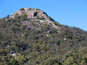
| Views of Castle Rock |
A gallery of photos of Castle Rock showing some of its many moods.
[15 photos] |
| At the Top |
A gallery of photos of some of the features on the top of Castle Rock as well as views of Girraween from its summit.
[11 photos] |
| October, 2009 – Pt 1 |
This is a series of photographs taken along the Castle Rock track. The sequence starts where the track begins at the Castle Rock Camping Area and ends where it joins with the Mt Norman track.
[185 photos] |
| October, 2009 – Pt 2 |
The continuation of the track from the Mt Norman fork to the summit of Castle Rock.
[122 photos] |
| February, 2011 |
This sequence of photos begins at the track entrance across the road from Gunn's Cottage and ends where it joins with the track from the Castle Rock Camping Area.
[71 photos] |