|
|
This track starts at a small carpark just off the side of Pyramids Road, some 4 km east of the information centre. After the first 300 metres, the track splits into two. The way on the left goes to Underground Creek. The gently-sloping path on the right leads to Dr Roberts' Waterhole, named after Dr Spencer Roberts who was fundamental in the creation of this national park. On the way to the waterhole, you might hear Superb Lyrebirds singing up in the hills. The waterhole is on Bald Rock Creek and its still, dark waters are a natural mirror to the bushland that surrounds it.
1.2 km
30 minutes return from Dr Roberts' carpark
Class 2 |
|
| Map |
A map of the walking track. |
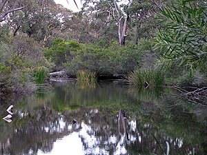
| Views of the Waterhole |
This calm stretch of water is home to a variety of native animals, including turtles, Eastern Water Dragons and platypus. It is also home to the introduced Carassius auratus, the feral Goldfish.
[12 photos] |
| May, 2009 |
This is a series of photographs taken along the track, late one afternoon.
[64 photos] |
| May, 2011 |
A series of photos taken along the track. This time, it was late morning.
[81 photos] |
|