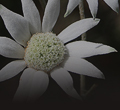
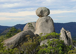
The track to The Sphinx and Turtle Rock is accessed from the Castle Rock track. It is a pleasant and moderately easy walk for people who wish to avoid exposed rock faces. The track follows a ridge-top southwards and, from the crest of the ridge, you can see Mt Norman. Along the way are heathlands, which, in Spring, are a wonderful wildflower display. The first major rock feature is The Sphinx. This is a granite pinnacle bearing a large balancing rock — an impressive sight. About 600 metres further south is Turtle Rock, which is a large granite monolith resembling a turtle's back.
|
|
7.4 km return
3 - 4 hours from the Visitor Information Centre
Classes 3 and 4 |
| Map |
A map of the walking track. |
| The Sphinx |
The Sphinx one of Girraween's most striking granite features.
[12 photos] |
| Turtle Rock |
Turtle Rock really does look like a turtle from some angles.
[12 photos] |
| Together |
The Sphinx and Turtle Rock are located on the same hill top.
[5 photos] |
| October, 2010 - The Sphinx |
This is a series of photographs taken along the Sphinx and Turtle Rock track. The sequence starts where the track begins at the Castle Rock track and ends at The Sphinx.
[207 photos] |
| October, 2010 - Turtle Rock |
This is a series of photographs taken along the Sphinx and Turtle Rock track. The sequence starts at the base of The Sphinx and ends at Turtle Rock.
[71 photos] |