This track starts at a small carpark just off the side of Pyramids Road, some 4 km east of the information centre. After the first 300 metres, the track splits into two. The way to the right goes to Dr Roberts' waterhole. The way to the left, the Underground Creek track, follows Bald Rock Creek upstream to where it disappears beneath a tumble of granite boulders that have fallen from an overhanging cliff. The gently-graded track is easy walking through a variety of landscapes and has good birdwatching opportunities.
2.8 km
1 - 1.5 hours return from Dr Roberts' carpark
Class 3 |
|
| Map |
A map of the walking track. |
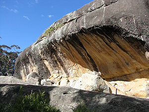
| Beneath the Cliff |
A gallery of photographs taken at the "underground" part of Underground Creek, where Bald Rock creek flows beneath huge boulders fallen from the granite cliff arching above.
[16 photos] |
| The Cave |
There is a cave hidden away beneath the rocks, where the granite has been polished smooth by running water.
[2 photos] |
| Above the Cliff |
These photographs are of the area on the granite shelf, up behind the cliff.
[18 photos] |
| The Walking Track – July 2009 |
This series of photographs was taken along the track to where the creek emerges from beneath the granite boulders.
[120 photos] |
| Underground Creek – July 2009 |
A sequence of photos taken at the "underground" part of Underground Creek.
[68 photos] |
| Behind the Cliff – July 2009 |
Take the side track around and up onto the granite shelf where Bald Rock creek flows before tumbling beneath the boulders.
[193 photos] |