Like many parts of Queensland, Girraween National Park received substantial rainfall during the Spring and Summer of 2010. In the first week of January 2011, 250mm fell on top of an already saturated ground and flowed into full creek systems.
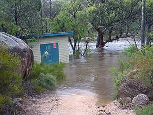
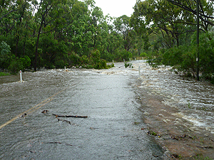
On the 11th of January, after a further 120mm of rainfall, floodwaters not only washed out minor and major roads, but most of Girraween's walking tracks and fire trails. The pump shed that houses Girraween's water treatment system was inundated and damaged, affecting the water supply. The park was immediately closed to the public.
As soon as the floodwaters receded from the roads, campers were able to continue on their way and park staff began the task of cleaning up. It took many weeks of hard work to clean and repair Girraween's infrastructure. This had been Girraween's highest and most damaging flood in decades.
On 17th February, with the reopening of Pyramids Road by the local council, Girraween National Park was once again welcoming visitors.
Initially, only the Castle Rock Camping Area and the following tracks were open for use:
Castle Rock track;
The Sphinx and Turtle Rock track;
Mt Norman track;
The Pyramid track;
and the northen section of the Granite Arch track.
Notices were posted around the park to let visitors know of track closures. Messages were also posted on the Queensland Government's Park Alerts page at regular intervals, updating the public of the progress that was being made.
Over the next few months the Bald Rock Creek Camping Area was reopened, as were:
Dr Roberts' Waterhole track;
Underground Creek track;
the southern section of the Granite Arch track;
and The Circuit track.
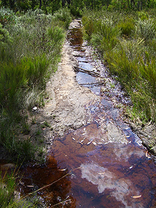
The last track to reopen was Girraween's extremely popular and environmentally sensitive The Junction Track. This track was the worst affected by the floods, as some sections were completely washed away and had to be rebuilt from scratch. During the planning stages of its repair, it was proposed that bags of decomposed granite be dropped in along the track by helicopter, rather than using large, cumbersome machinery to carry the materials in through delicate areas. In the end, the helicopter wasn't used. The track was reopened in time for visitors to enjoy the Spring wildflowers.
Mt Norman Road was badly washed out by the floods. The section from Wallangarra to the day-use area has reopened, but the 4WD only section is still closed (May 2012) and undergoing repairs.
The dedicated Girraween staff have worked hard to fix the damage caused by the floods and the Girraween Management Unit has applied for natural disaster funding in assistance to their effort.
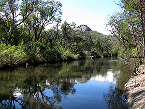
Mother Nature is also doing her part to help. Girraween has never looked so beautiful. The creeks are full, the landscape is lush and green, and there is abundant food for all creatures great and small. No doubt next Spring will bring extraordinarily beautiful wildflower displays. So while Mother Nature's forces can be challenging at times, there is always the flipside!
Girraween Park Rangers
More Photos of the 2011 Flood...
The 1976 Flood
The 2008 Flood
Next...
Wild Winds.
|